The 417 Expressway: Orlando's Eastern Beltway Explained
The Central Florida GreeneWay isn't just a toll road — it's the spine of Orlando's east side, and a quiet factor in where a lot of people end up buying.
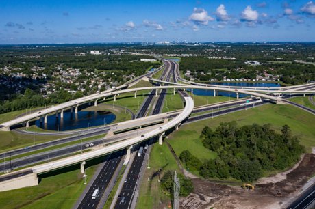
The 417 Expressway is State Road 417, a 55-mile toll road that forms the eastern and southern beltway around Orlando, FL, running from I-4 near Celebration to I-4 in Sanford through Osceola, Orange, and Seminole counties. Its official name is the Central Florida GreeneWay in Orange County and the Seminole Expressway in Seminole County. It is jointly operated by the Central Florida Expressway Authority (CFX) and Florida's Turnpike Enterprise, with CFX running the 33-mile central section. The first segment opened December 16, 1988, and the road was named the GreeneWay in 1993 after CFX board chairman James B. Greene. The 417 uses all-electronic tolling via E-PASS or SunPass and provides direct access to Orlando International Airport (MCO).
If you're house-hunting on the east or south side of Orlando, one road keeps showing up — on every drive-time estimate, every "how far is the airport" question, every conversation about why one neighborhood feels more connected. That road is the 417.
Locals call it "the 417," the "GreeneWay," or the eastern beltway. Here's our take: it's one of the most underrated factors in choosing where to live out here. It doesn't make the relocation brochures, but it quietly shapes commute times, airport runs, and home values across a huge swath of the metro. Let's break down what it is, how it came together, and what those tolls really cost.
What Exactly Is the 417?
The 417 is a 55-mile, limited-access toll road that wraps around the east and south sides of Orlando like a giant horseshoe. It starts at Interstate 4 near Celebration, swings east past the airport and the UCF area, then runs north into Seminole County before tying back into I-4 in Sanford.
A naming quirk that trips up newcomers: the road has more than one official name. Through Orange County — the central 33 miles, and the busiest stretch — it's the Central Florida GreeneWay. In Seminole County to the north, it becomes the Seminole Expressway. You'll also hear "Eastern Beltway" or "Orlando East Bypass." Everyone just says "417."
It's also run by two different agencies, which matters when you set up a toll account. The Central Florida Expressway Authority (CFX) operates the 33-mile GreeneWay through Orange County, while Florida's Turnpike Enterprise runs the two end pieces — the roughly 6-mile Southern Connector down to I-4 near the theme parks, and the 17-mile Seminole Expressway up to Sanford. Three counties, two operators, one road.
A Quick History (How the Beltway Came to Be)
In the 1980s, getting around Orlando's exploding east side meant crawling along Semoran Boulevard or fighting I-4. The fix was a bypass, built in stages over more than a decade.
The first segment opened December 16, 1988, giving commuters an alternative to Semoran and an express link to the University of Central Florida. In 1993, the Orange County portion was named the Central Florida GreeneWay for James B. Greene, who chaired the regional expressway board from 1971 to 1985 and championed the beltway as Disney-fueled growth overwhelmed local roads. The 22-mile stretch connecting the Beachline (SR 528) to International Drive opened in 1998, with the northern Seminole Expressway leg finished into the early 2000s.
The 417 was originally meant to be a full loop. Planners eventually split it — the east side kept the 417 designation, the west side became the SR 429 Western Beltway. The systems interchange tying the 417 into Florida's Turnpike wrapped up in 2021, and the loop finally closed in 2024 when the Wekiva Parkway joined the 417 and 429 around the north end — a beltway more than 35 years in the making.
Why the 417 Matters If You're Moving to Orlando's East Side
Airport Access That's Genuinely Hard to Beat
The single biggest draw is speed to the airport. The 417 provides a direct southern connection to Orlando International Airport (MCO). From Lake Nona, you can realistically be curbside in about 10 minutes — a big reason Lake Nona and its Medical City job hub took off the way they did. If you fly often for work, that convenience is worth real money.
Skipping I-4 and Downtown Entirely
Let's be real: I-4 is the road everyone loves to hate. The 417's whole purpose is to move you north-south on the east side without touching it. It ties into the 408 East-West Expressway when you do need to dart into Downtown Orlando, but most days it lets you skip that congestion altogether. For Seminole County commuters, the northern leg also feeds toward Orlando Sanford International Airport.
The Communities It Opened Up
The 417 didn't just serve existing neighborhoods — it helped create them. The corridor runs past or near some of the metro's fastest-growing areas: Lake Nona, Hunter's Creek on the south side, the UCF area and Oviedo to the northeast, and Celebration and Kissimmee near the southern I-4 tie-in. If a listing brags about "quick highway access" on the east side, the 417 is usually what it means.
The Toll Reality (Budget for It)
Here's what nobody puts in the listing: the 417 is tolled end to end, and it adds up daily. A few practical truths:
- Get a transponder. The GreeneWay is all-electronic — no cash booths, just overhead gantries. E-PASS (CFX) and SunPass (Florida's Turnpike) both work the entire length and are interoperable, so either tag is fine.
- Skipping the tag costs more. Without one you're billed by mail at higher "toll-by-plate" rates. E-PASS customers save roughly 30% versus cash and about 50% versus toll-by-plate.
- Per-trip it's modest; daily it stacks. Under recent schedules, individual E-PASS segment tolls for a car have run roughly $0.50 to about $1.55, and a full run passes several tolling points.
One caveat on numbers: tolls rose with an annual inflation-indexed adjustment effective January 1, 2026, so older calculators may read slightly low. For the exact cost of a specific trip, use the official CFX or Florida's Turnpike toll calculator. If you're weighing a long daily toll commute, fold it into the bigger picture — see our honest cost of living in Orlando guide.
Living Along the 417: Pros and Cons
The Pros
- Fast, predictable access to MCO and the east-side job centers
- A genuine alternative to I-4 for north-south trips
- Connects to the 408, the Beachline, and the Turnpike, so most of the metro is reachable without surface-street slogs
- Anchors high-growth communities like Lake Nona, Hunter's Creek, and the Oviedo/UCF area
The Cons
- Tolled the entire way — a daily cost that surface-road drivers don't pay
- No cash option on the all-electronic sections, so a transponder is effectively required
- Three counties and two operators can confuse first-time account setup
Our Take
If your daily life involves the airport, the east-side tech and medical corridors, or simply avoiding I-4, the 417 is a feature, not a bug — budget the tolls and enjoy the time you save. If you rarely head that way, you may not need to pay a premium to live right on it. It comes down to where your week actually takes you, which is exactly what our geography of Orlando guide is built to help with.
What the Neighbors Know
People who've lived here a while don't think of the 417 as "a toll road" — they think of it as the reason a 40-minute slog became a 15-minute hop. They keep a transponder in every car and fold the monthly toll bill into their housing math the same way they factor insurance.
The corridor it created spans three counties and is still shaping where Orlando grows. Whether the 417 belongs in your commute comes down to one question: does your week point east and south? If so, living near it is one of the better quality-of-life moves you can make out here. 🛣️
For route maps, current tolls, and construction updates, visit the official Central Florida GreeneWay (SR 417) page from CFX.
Trying to figure out which east-side or south-side community fits your commute? Explore homes in Lake Nona, Hunter's Creek, and Oviedo, or contact us for personalized relocation advice!