Orange Blossom Trail: Central Florida's Original Main Road
The story behind US 441 — the 400-mile highway that helped build Orlando long before I-4 ever existed
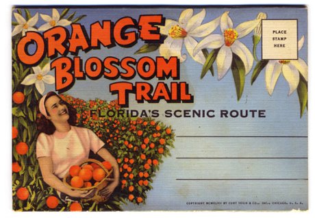
The Orange Blossom Trail (OBT) is the local name for U.S. Route 441 as it passes through Central Florida. For about 30 miles between Kissimmee and Apopka it runs concurrent with US 17 and US 92 and travels directly through Orlando. US 441 is a 400-plus-mile federal highway running from Miami to the Georgia state line, and through the 1950s and 1960s OBT was Central Florida's premier north-south route for tourists. Today the corridor ranges from busy suburban retail near the Florida Mall to a roughly seven-mile Orlando urban stretch, between Colonial Drive and Sand Lake Road, that has been the focus of redevelopment since the Orange Blossom Trail Development Board formed in 1985.
Here's a road you've almost certainly driven, probably without giving it a second thought: Orange Blossom Trail. Locals just call it "OBT," and depending on which stretch you're on, it can feel like a different highway entirely. So before the reputation gets a word in, let's set the record straight — because there's a lot more to this one than most people realize.
OBT isn't some minor surface street. It's U.S. Route 441, a federal highway that runs more than 400 miles from Miami up to the Georgia line. And in Central Florida, it was here first — this was the main road into Orlando back when "the attractions" meant citrus stands and roadside motels, not theme parks.
So What Exactly Is the Orange Blossom Trail?
Officially, OBT is the Central Florida designation for US 441. For roughly 30 miles between Kissimmee and Apopka, the highway runs together with US 17-92, which is why you'll sometimes see a confusing stack of route shields on the same pole. The name itself is a nod to Florida's citrus heritage — back when this corridor cut straight through orange groves in bloom.
If you're house-hunting and a listing mentions OBT, US 441, or "the Trail," they're all the same road. What changes — dramatically — is the neighborhood around it.
Florida's Original Tourist Highway
Here's the fun fact for your next dinner party: in the 1950s and '60s, Orange Blossom Trail was Orlando tourism. It was the area's premier north-south route, lined with hotels, restaurants, and the kind of neon roadside businesses that defined mid-century Florida travel. If you were driving down to see the springs, the citrus towers, or early Central Florida attractions, you did it on OBT.
Then everything changed. When Interstate 4 opened and Walt Disney World arrived in 1971, the tourist traffic shifted to the interstate practically overnight. The grand old motels on OBT lost their reason for being, and over the following decades parts of the corridor slid into disinvestment. That's the short version of how a once-glamorous highway picked up a reputation it's still working to shed.
Following 441 Beyond the Metro
Most people only ever experience the Orlando slice of OBT, but the highway keeps going in both directions — and that's where it gets interesting for anyone exploring where to put down roots.
Heading south, US 441 pairs up with US 192 (Irlo Bronson Memorial Highway) for about 15 miles through Osceola County before splitting off and turning north in downtown Kissimmee. This is the tourist-corridor end of things, with easy reach to the parks and a deep bench of dining and retail — you can browse our complete Kissimmee restaurants and dining guide for a sense of what's down there.
Heading north, 441 leaves Orlando, crosses the toll-road tangle of SR 429 near Apopka, then rolls into Lake County. From here it becomes genuinely scenic, threading through the chain-of-lakes towns of Mount Dora, Eustis, and Tavares — historic downtowns and waterfront views that feel a world away from the urban core — before joining US Highway 27 at Leesburg. Same highway number, completely different vibe.
Let's Be Real About the Urban Stretch
We're not going to pretend the reputation came from nowhere. The part of OBT that earned it is a roughly seven-mile urban stretch in Orlando, between Colonial Drive (SR 50) and Sand Lake Road, where you'll find aging motels, pawn shops, and pockets of crime that have been a documented concern for decades. It's the kind of corridor where many longtime locals will tell you to use the 408 Expressway or John Young Parkway as alternatives, especially after dark.
That said, it's still a working artery that runs right through the heart of the city and connects to Downtown Orlando. Tens of thousands of ordinary commuters, workers, and shoppers use it every single day. The honest read isn't "avoid OBT" — it's "know which segment you're in," because the character genuinely changes block by block.
The Comeback Story
What a lot of people don't know is that there's an organized, decades-long effort to turn the urban corridor around. The Orange Blossom Trail Development Board has been working on exactly this since 1985, in partnership with the City of Orlando, Orange County, and the Florida Department of Transportation.
Their "OBT Next" master plan lays out a long-term strategy for an eight-mile section of the Trail — everything from infrastructure and streetscape improvements to park reconstruction and new housing. It's slow, generational work, but it means the corridor's future isn't being left to chance. For relocating buyers, that's a meaningful signal: the cheap-today blocks may not stay overlooked forever.
What This Means If You're House-Hunting Near OBT
So should a home near Orange Blossom Trail be on your list? Here's our honest take.
The Pros:
- Central location — OBT links Kissimmee, south Orlando, downtown, and Apopka along one straight north-south line
- Commercial convenience, with major retail like The Florida Mall (300-plus stores, 20+ million visitors a year) sitting right on the corridor
- Generally more affordable housing than you'll find on the west side or near the parks
- Active, funded redevelopment in the urban core
The Cons:
- The Colonial-to-Sand Lake stretch still carries real safety and blight concerns
- Heavy commercial traffic and a stop-light-heavy drive on the busiest sections
- Quality varies sharply from one block to the next, so two homes on "OBT" can be nothing alike
Our Take:
If you're drawn to the affordability and central access, focus on the suburban ends — the Kissimmee side or the Lake County towns up north — and tour any prospective block in person, day and night. If you want quiet and predictability, you'll likely be happier a bit off the corridor. Either way, judge the specific neighborhood, not the highway's name. A little homework along the Trail goes a long way — and our Kissimmee shopping guide is a good place to see how lively the southern end has become.
What the Neighbors Know
Ask anyone who's lived here a while and they'll tell you the same thing: Orange Blossom Trail isn't one place, it's a dozen. It's the citrus-era highway that put Orlando on the map, the tourist drag near the parks, the busy retail run past the Florida Mall, the gritty-but-improving urban core, and the postcard-pretty route through the Lake County lakes. The reputation is real for one slice of it — and unfair to all the rest.
For a relocating family, the takeaway is simple. OBT is a fantastic shorthand for "centrally located and affordable," but it demands a closer look than almost any other road in the metro. Drive the exact stretch you're considering, check it at different hours, and you'll quickly see why the locals never lump it all together. Do that, and the Trail can hold some genuinely smart buys. 🍊
For corridor plans, redevelopment projects, and current initiatives, visit the official Orange Blossom Trail Development Board website.
Trying to figure out which Central Florida corridor fits your move? Explore our Kissimmee and Downtown Orlando guides, or Contact Us for personalized relocation advice along OBT and beyond!